About Hungry Point
 Historical pictures
and narrative of Hungry Point. Located: Dickerson Bay, Panacea,
Florida, USA.
Developed 1955-1960 by Don Phillips, Clinton Pigott, Mac McKinnon, Gene
Phipps, ??? Amundsen, and others. ??? professed to be relation of Roald
Amundsen, leader of the first successful Antartic southpole expedition
in 1910-1912 (Amundsen had a small store next to the barbershop in
Panacea at the time, his first name and familial relationship to Roald
Amundsen, the explorer, require further verification).
Historical pictures
and narrative of Hungry Point. Located: Dickerson Bay, Panacea,
Florida, USA.
Developed 1955-1960 by Don Phillips, Clinton Pigott, Mac McKinnon, Gene
Phipps, ??? Amundsen, and others. ??? professed to be relation of Roald
Amundsen, leader of the first successful Antartic southpole expedition
in 1910-1912 (Amundsen had a small store next to the barbershop in
Panacea at the time, his first name and familial relationship to Roald
Amundsen, the explorer, require further verification).
 In the early to mid 1950's Don Phillips performed a beach replenishment
"dredge and fill" operation for the city of Panacea at Wooley Beach.
Now known as Wooley Park, and the current site of the Annual
Panacea Blue Crab Festival. Some lots currently owned by the
Phillips family in Agua da Vida subdivision
were received as partial payment for Don Phillips work at Wooley Beach.
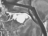
Although taken in 1937 the picture at right is likely representative of
Hungry Point as Don first saw it, a low lying oyster bar of marsh grass
with a narrow beach along much of the shoreline.
In the early to mid 1950's Don Phillips performed a beach replenishment
"dredge and fill" operation for the city of Panacea at Wooley Beach.
Now known as Wooley Park, and the current site of the Annual
Panacea Blue Crab Festival. Some lots currently owned by the
Phillips family in Agua da Vida subdivision
were received as partial payment for Don Phillips work at Wooley Beach.
Although taken in 1937 the picture at right is likely representative of
Hungry Point as Don first saw it, a low lying oyster bar of marsh grass
with a narrow beach along much of the shoreline.
Sometime after the Wooley Beach job, work at Hungry Point began.
Starting at the mainland
where Chickasaw Street ended between lots 1,2,3 and 14,15 of Agua Da
Vida subdivision, a "dragline" was employed scooping up sea bottom to
create a bridging isthmus roadbed out to Hungry Point located
some 300 feet to the North East.
 Once the mainland and
spit were thus bridged the west most land area of Hungry Point was
expanded
to an upland area of about 1/2 acre for placement of a storage facility
and lodging. Along the west facing shoreline an
"L" shaped 175' length of Bulkhead for boat moorage and docking was
installed. As of Feb 14, 2007 the bulkhead parcel surveyed
to 2.07 acres. Total water frontage of 1200', 1/2 acre of upland, 1/2
acre wetland, and 1 acre marsh. Literally a stone's throw to Port
Panacea Marina, Hook Wreck Henry's Bar and Grill, and the Harbor House
Seafood Restaurant.
This property is For Sale.
Once the mainland and
spit were thus bridged the west most land area of Hungry Point was
expanded
to an upland area of about 1/2 acre for placement of a storage facility
and lodging. Along the west facing shoreline an
"L" shaped 175' length of Bulkhead for boat moorage and docking was
installed. As of Feb 14, 2007 the bulkhead parcel surveyed
to 2.07 acres. Total water frontage of 1200', 1/2 acre of upland, 1/2
acre wetland, and 1 acre marsh. Literally a stone's throw to Port
Panacea Marina, Hook Wreck Henry's Bar and Grill, and the Harbor House
Seafood Restaurant.
This property is For Sale.
 The first phase of
development was so successful that some months later the effort was
expanded and the "dragline" progressed steadily toward the east over a
period of weeks and months. The upland area was thus expanded.
Eventually terminating at the eastern
end of the Hungry Point spit with a resulting total beach shoreline
length of over 1000 feet and upland width of some 50-75 feet.
This expansion was simply used as a beach and nature walk with no other
intended use for several years.
The first phase of
development was so successful that some months later the effort was
expanded and the "dragline" progressed steadily toward the east over a
period of weeks and months. The upland area was thus expanded.
Eventually terminating at the eastern
end of the Hungry Point spit with a resulting total beach shoreline
length of over 1000 feet and upland width of some 50-75 feet.
This expansion was simply used as a beach and nature walk with no other
intended use for several years.
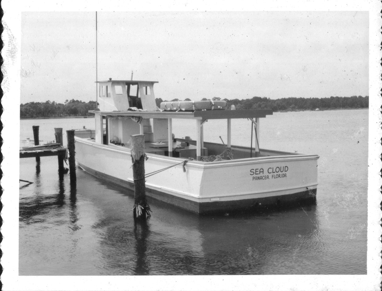
 Following consultation
between Eugene Phipps (yes, THOSE Phipps) and Phillips the project
morphed in to a deep sea party boat fishing operation
dubbed the Sea Cloud Corporation. A surplus coast guard boat was
procured, new engines were purchased and installed, and a boarding dock
was built.
With the infrastructure in place operations began and continued for
several years with clientele coming from as far away as Alabama and
Mississippi to enjoy the excellent fishing and weather to be found at
Apalachee Bay in the 1950's.
Following consultation
between Eugene Phipps (yes, THOSE Phipps) and Phillips the project
morphed in to a deep sea party boat fishing operation
dubbed the Sea Cloud Corporation. A surplus coast guard boat was
procured, new engines were purchased and installed, and a boarding dock
was built.
With the infrastructure in place operations began and continued for
several years with clientele coming from as far away as Alabama and
Mississippi to enjoy the excellent fishing and weather to be found at
Apalachee Bay in the 1950's.
 Around 1959 the
United States Corp of Engineers was scheduled to dredge a navigable
channel at Panacea. Initially the Corp was pumping the "spoil" to
Porter Island, approximately 1/2 mile to the east.
This was quite a ways to pump the sand, shell, and mud mixture of
"spoil". Phillips noticing this inquired of the Corp's foreman if it
would be advantageous to pump some of the spoil on to the area adjacent
to the Hungry Point. More specifically to the south side of Don's
recently completed landbridge... and if so... what would it take?.
Around 1959 the
United States Corp of Engineers was scheduled to dredge a navigable
channel at Panacea. Initially the Corp was pumping the "spoil" to
Porter Island, approximately 1/2 mile to the east.
This was quite a ways to pump the sand, shell, and mud mixture of
"spoil". Phillips noticing this inquired of the Corp's foreman if it
would be advantageous to pump some of the spoil on to the area adjacent
to the Hungry Point. More specifically to the south side of Don's
recently completed landbridge... and if so... what would it take?.
The answer to, what it would take?, was... "A bottle of
whiskey!". Whiskey (brand unknown) was secured and delivered and
pumping commenced. Pumping continued for several weeks or months. Upon
completion the resulting spoil mound was 50 feet high covering close to
6 acres...
- Larger Photos
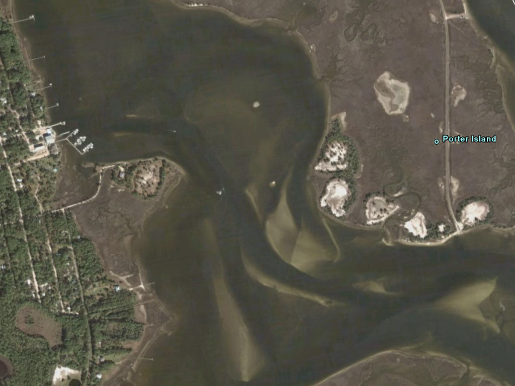
- 1999
USGS photo, 05-Jan-1999.
- 2007
Google Earth, 02-26-2007.
- County Letter
- Peninsula 1/4 size
- Plats 1/4 size
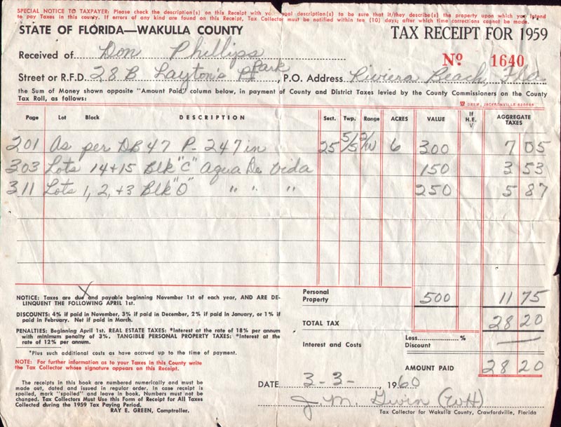
- tax receipt,
1957
- tax receipt,
1958
- tax receipt,
1959
- tax Receipt,
1960
- Property Deed, 1956
- Sea Cloud, a "Party"
boat, 1958.
- Dragline, used to
build road and peninsula, 1956.
- Charlottes
Timeline, 1958
- Fred
Cross Letter, peninsula and Zora.
 Historical pictures
and narrative of Hungry Point. Located: Dickerson Bay, Panacea,
Florida, USA.
Developed 1955-1960 by Don Phillips, Clinton Pigott, Mac McKinnon, Gene
Phipps, ??? Amundsen, and others. ??? professed to be relation of Roald
Amundsen, leader of the first successful Antartic southpole expedition
in 1910-1912 (Amundsen had a small store next to the barbershop in
Panacea at the time, his first name and familial relationship to Roald
Amundsen, the explorer, require further verification).
Historical pictures
and narrative of Hungry Point. Located: Dickerson Bay, Panacea,
Florida, USA.
Developed 1955-1960 by Don Phillips, Clinton Pigott, Mac McKinnon, Gene
Phipps, ??? Amundsen, and others. ??? professed to be relation of Roald
Amundsen, leader of the first successful Antartic southpole expedition
in 1910-1912 (Amundsen had a small store next to the barbershop in
Panacea at the time, his first name and familial relationship to Roald
Amundsen, the explorer, require further verification).


